-
 Police arrest suspect who set woman on fire in New York subway
-
China vows 'cooperation' over ship linked to severed Baltic Sea cables

-
 Australian tennis star Purcell provisionally suspended for doping
-
Luxury Western goods line Russian stores, three years into sanctions

-
 Wallace and Gromit return with comic warning about AI dystopia
-
Philippine military says will acquire US Typhon missile system

-
 Afghan bread, the humble centrepiece of every meal
-
Honda and Nissan expected to begin merger talks

-
 'Draconian' Vietnam internet law heightens free speech fears
-
Israeli women mobilise against ultra-Orthodox military exemptions

-
 Asian markets track Wall St rally as US inflation eases rate worries
-
Tens of thousands protest in Serbian capital over fatal train station accident

-
 Trump vows to 'stop transgender lunacy' as a top priority
-
'Who's next?': Misinformation and online threats after US CEO slaying

-
 Only 12 trucks delivered food, water in North Gaza Governorate since October: Oxfam
-
Langers edge Tiger and son Charlie in PNC Championship playoff

-
 Explosive batsman Jacobs gets New Zealand call-up for Sri Lanka series
-
Holders PSG edge through on penalties in French Cup

-
 Daniels throw five TDs as Commanders down Eagles
-
Atalanta fight back to take top spot in Serie A, Roma hit five

-
 Mancini admits regrets over leaving Italy for Saudi Arabia
-
Run machine Ayub shines as Pakistan sweep South Africa

-
 Slovak PM Fico on surprise visit to Kremlin
-
'Incredible' Liverpool must stay focused: Slot

-
 Maresca 'absolutely happy' as title-chasing Chelsea drop points in Everton draw
-
Salah happy wherever career ends after inspiring Liverpool rout

-
 Three and easy as Dortmund move into Bundesliga top six
-
Liverpool hit Spurs for six, Man Utd embarrassed by Bournemouth

-
 Netanyahu vows to act with 'force, determination' against Yemen's Huthis
-
Ali hat-trick helps champions Ahly crush Belouizdad

-
 Salah stars as rampant Liverpool hit Spurs for six
-
Syria's new leader says all weapons to come under 'state control'

-
 'Sonic 3' zips to top of N.America box office
-
Rome's Trevi Fountain reopens to limited crowds

-
 Mbappe strikes as Real Madrid down Sevilla
-
Pope again condemns 'cruelty' of Israeli strikes on Gaza

-
 Lonely this Christmas: Vendee skippers in low-key celebrations on high seas
-
Troubled Man Utd humiliated by Bournemouth

-
 2 US pilots shot down over Red Sea in 'friendly fire' incident: military
-
Man Utd embarrassed by Bournemouth, Chelsea held at Everton

-
 France awaits fourth government of the year
-
Death toll in Brazil bus crash rises to 41

-
 Odermatt stays hot to break Swiss World Cup wins record
-
Neville says Rashford's career at Man Utd nearing 'inevitable ending'

-
 Syria's new leader vows not to negatively interfere in Lebanon
-
Germany pledges security inquest after Christmas market attack

-
 Putin vows 'destruction' on Ukraine after Kazan drone attack
-
Understated Usyk seeks recognition among boxing legends

-
 France awaits appointment of new government
-
Cyclone Chido death toll rises to 94 in Mozambique


Mauritius braces for intense Cyclone Freddy
Mauritius was battening down the hatches on Monday as an intense tropical cyclone moved closer, with flights cancelled and normal life at a standstill in the Indian Ocean island nation.
No government services were operating, while shops, banks and petrol stations were shut and public transport halted, leaving streets largely deserted, according to an AFP correspondent.
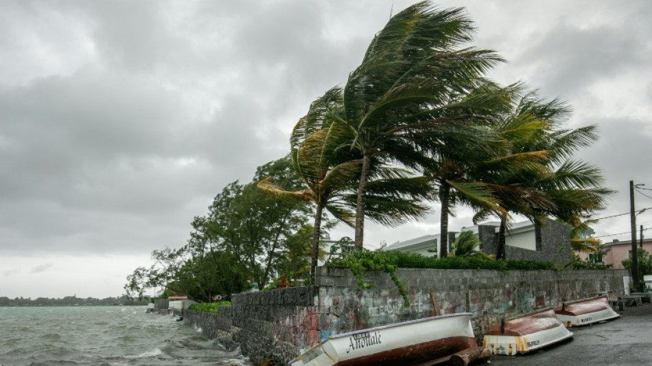
Images from the remote paradise island showed waves crashing to the shore and the wind whipping through palm trees.
"Cyclone Freddy is an extremely strong cyclone which is a direct threat" to the islands of Mauritius, Rodrigues and Saint-Brandon, Prime Minister Pravind Jugnauth said.
In an address late Sunday, he urged the people of Mauritius to take all necessary precautions, stay home and remain "vigilant."
The idyllic holiday destination is renowned for its spectacular white sandy beaches and turquoise waters but also lies in the pathway of occasional cyclones.
The Mauritius Meteorological Services (MMS) has issued a Class 3 cyclone warning, saying estimated gusts in the centre of Cyclone Freddy could reach around 280 kilometres (170 miles) an hour.
- 'Storm surge' -
In its latest update at 4 pm (1200 GMT), the agency said Freddy was about 120 kilometres to the north of Mauritius and moving west-southwest at a speed of about 30 kilometres an hour.
A slight change of trajectory towards the south "may still bring the centre of Freddy closer to Mauritius," the MMS said, warning that a "further deterioration" in the weather is expected in the coming hours.
"Sea will be phenomenal with heavy swells of the order of seven metres beyond the reefs. Storm surge will continue to cause inundation along the low-lying coastal areas. It is, therefore, strictly advised not to go at sea," it added.
"The public in Mauritius is advised to maintain all precautions and to stay in safe places."
The agency had earlier lowered the cyclone's classification to intense from very intense and lifted its safety bulletin for the autonomous island of Rodrigues which lies 600 kilometres east of Mauritius.
Airports of Mauritius announced that the international airport would be closed from Monday until further notice "due to the cyclonic weather".
"Air Mauritius is closely monitoring the situation with the authorities and will keep passengers informed of developments," the national carrier added on its website.
The authorities on the French island of Reunion, which is expecting the cyclone to reach it overnight Monday, have also gone on alert.
About a dozen storms or cyclones occur each year in the southwest Indian Ocean during the November-April season.
strs-txw/lc
Nogueira--PC


