-
 Hawaii's Kilauea volcano erupts, spewing columns of lava
-
El Salvador Congress votes to end ban on metal mining

-
 Five things to know about Panama Canal, in Trump's sights
-
NBA fines Minnesota guard Edwards $75,000 for outburst

-
 Haitians massacred for practicing voodoo were abducted, hacked to death: UN
-
Inter beat Como to keep in touch with leaders Atalanta

-
 Man Utd boss Amorim questions 'choices' of Rashford's entourage
-
Trump's TikTok love raises stakes in battle over app's fate

-
 Is he serious? Trump stirs unease with Panama, Greenland ploys
-
England captain Stokes to miss three months with torn hamstring

-
 Support grows for Blake Lively over smear campaign claim
-
Canada records 50,000 opioid overdose deaths since 2016

-
 Jordanian, Qatari envoys hold talks with Syria's new leader
-
France's second woman premier makes surprise frontline return

-
 France's Macron announces fourth government of the year
-
Netanyahu tells Israel parliament 'some progress' on Gaza hostage deal

-
 Guatemalan authorities recover minors taken by sect members
-
Germany's far-right AfD holds march after Christmas market attack

-
 Serie A basement club Monza fire coach Nesta
-
Mozambique top court confirms ruling party disputed win

-
 Syrian medics say were coerced into false chemical attack testimony
-
NASA solar probe to make its closest ever pass of Sun

-
 London toy 'shop' window where nothing is for sale
-
Volkswagen boss hails cost-cutting deal but shares fall

-
 Accused killer of US insurance CEO pleads not guilty to 'terrorist' murder
-
Global stock markets mostly higher

-
 Not for sale. Greenland shrugs off Trump's new push
-
Acid complicates search after deadly Brazil bridge collapse

-
 Norwegian Haugan dazzles in men's World Cup slalom win
-
Arsenal's Saka out for 'many weeks' with hamstring injury

-
 Mali singer Traore child custody case postponed
-
France mourns Mayotte victims amid uncertainy over government

-
 UK economy stagnant in third quarter in fresh setback
-
African players in Europe: Salah leads Golden Boot race after brace

-
 German far-right AfD to march in city hit by Christmas market attack
-
Ireland centre Henshaw signs IRFU contract extension

-
 Bangladesh launches $5bn graft probe into Hasina's family
-
US probes China chip industry on 'anticompetitive' concerns

-
 Biden commutes sentences for 37 of 40 federal death row inmates
-
Clock ticks down on France government nomination

-
 Mozambique on edge as judges rule on disputed election
-
Mobile cinema brings Tunisians big screen experience

-
 Honda and Nissan to launch merger talks
-
Police arrest suspect who set woman on fire in New York subway

-
 China vows 'cooperation' over ship linked to severed Baltic Sea cables
-
Australian tennis star Purcell provisionally suspended for doping

-
 Luxury Western goods line Russian stores, three years into sanctions
-
Wallace and Gromit return with comic warning about AI dystopia

-
 Philippine military says will acquire US Typhon missile system
-
Afghan bread, the humble centrepiece of every meal


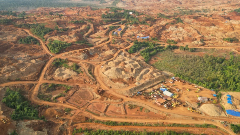
Satellite images show deforestation toll of Indonesia mines
More than 700,000 hectares of forest in Indonesia have been cleared for mining since 2001, including large tracts of primary forest, a new analysis using satellite data has found.
The TreeMap, a conservation start-up, used high-resolution imagery from several satellites and two decades of data from the long-running Landsat programme to map mines and related infrastructure and track deforestation.
It estimates that mining -- including pits, processing facilities, tailings areas and roads -- resulted in the clearing of 721,000 hectares (7,210 square kilometres) of forest between 2001 and 2023.
An estimated 150,000 hectares of that was primary forest, areas with high carbon stock and tall trees that include intact old growth, according to the analysis released this week.
The group's Nusantara Atlas shows the striking disappearance of forest cover in time-lapse sequences as mines and associated infrastructure are developed.
The mines were identified using a combination of "visual interpretation and machine learning", explained David Gaveau, founder of The TreeMap.
"Open-pit mines are easily identified... by their concentric lines of benches cut into the pit sides for coal mines, or by their tendency to be located along river banks, for gold," he explained.
All types of mines also have distinctive "spectral signatures" -- a measurement of energy -- that are characteristic of bare land areas and are easily detectable, he added.
The group cross-referenced their findings with official maps of mining concessions, local media articles and NGO reports.
Using historical satellite images also allowed them to detect now-abandoned mines that have become overgrown.
The impact from coal mining was by far the largest, accounting for around half of all the deforestation tracked, followed by gold, tin and nickel.
And while the data showed a peak in deforestation in 2013, the problem has begun growing again in recent years.
By 2023, mining was linked to an annual loss of nearly 10,000 hectares of primary forest, Gaveau said.
Indonesia's environment ministry did not respond to a request for comment on the analysis.
The government's latest public figures, which are not broken down by cause, say over 73,000 hectares of forest area was lost in 2021-22, with more than 104,000 hectares of total deforestation that year, including "non-forest area".
Deforestation linked to mining still falls far short of the forest loss caused by palm oil and wood plantations.
But it is an area of growing concern, with Indonesia's reliance on coal increasing and the country looking to expand exploitation of its nickel reserves.
Indonesia has the world's largest reserves of highly sought-after nickel, a crucial component for the batteries used in electric vehicles.
A 2022 study found that 80 percent of global forest loss linked to mining occurred in just four countries: Indonesia, Brazil, Ghana and Suriname.
Indonesia was by far the worst affected however, accounting for nearly 60 percent of the global mining-linked forest loss tracked in the study.
A.P.Maia--PC


